The following is a brief account of a walk in 1992 round the perimeter ridge of Wilpena Pound completed by Steve Weir and Graham Dingley with Jan Dingley supplying back up support.
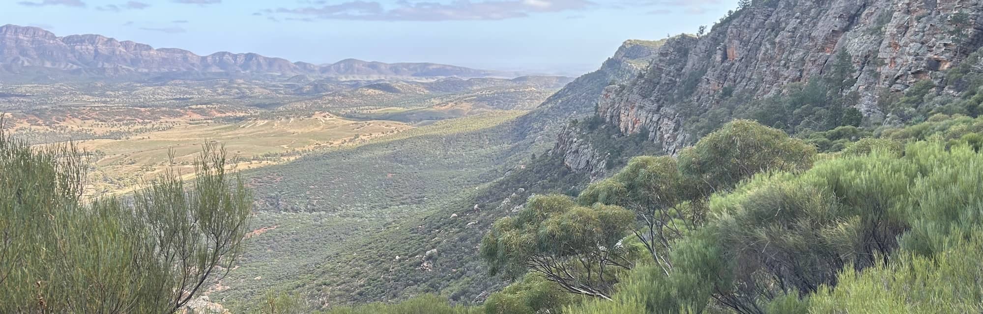
Anyone visiting Wilpena Pound can’t help noticing the broken ridge running all the way from Pompey Pillar to St. Mary’s Peak – that’s what makes it the ‘Pound’. It’s such an obvious feature that the idea of walking round the ridge probably jumps to most walker’s minds when they see it. To us it looked like a fair challenge so we bit the nettle, grasped the bullet and set off early on Friday 11th of September with plenty of water and a bit of trepidation.
Day 1
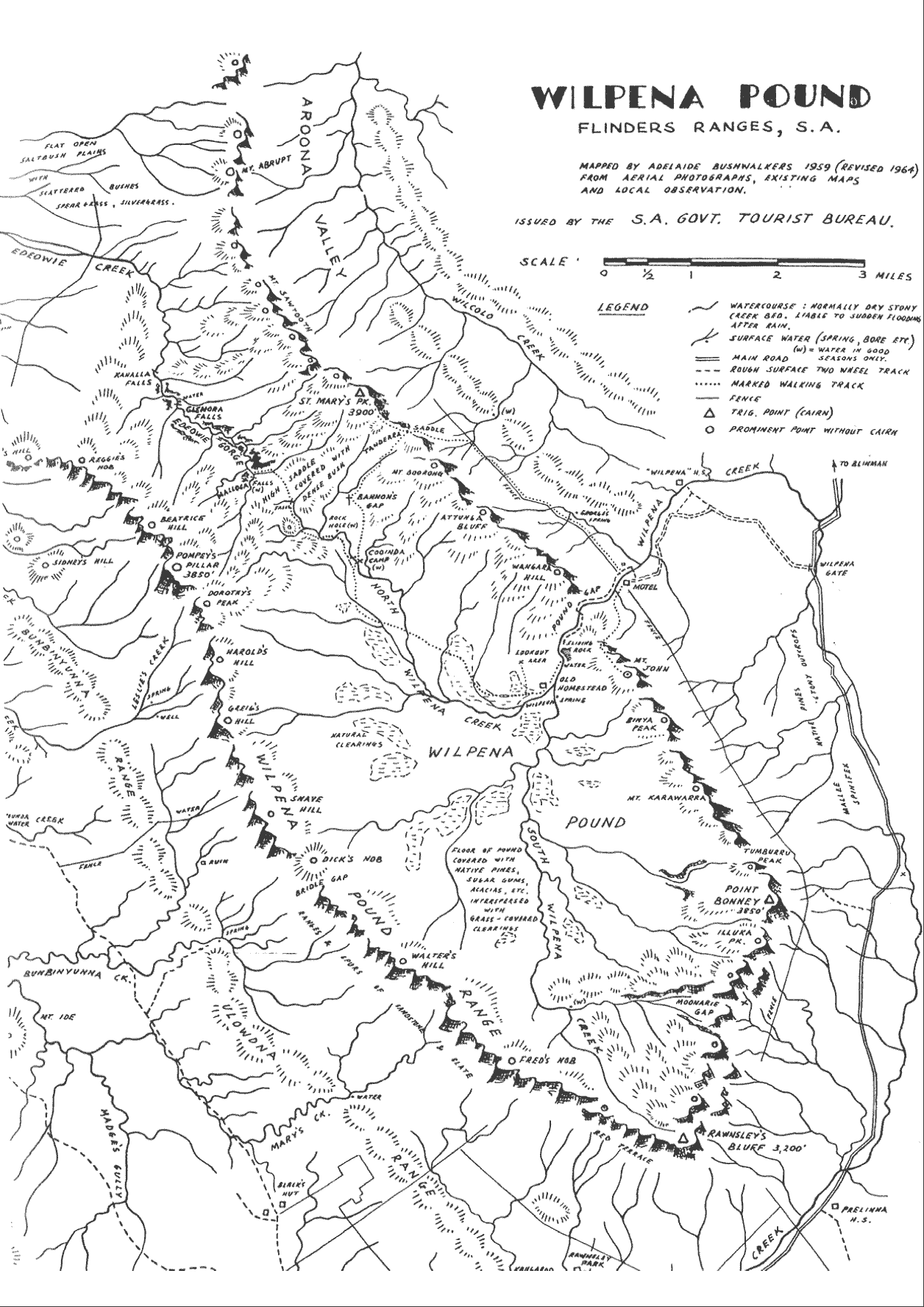
Jan dropped us off at the footpath to Arkaroo Rock at 7 am and we made our way up to Moonarie Gap. Our clockwise route took us south to the top of Moonarie crag -the spectacular climbing area catching the morning sun.
The climb to the top of Moonarie was the longest that day but as we were fresh it didn’t bother us much. We were surprised by the slow progress due to rocky terrain and vegetation. The big fire about 5 years ago cleared a lot of bushes – leaving charcoal covered shoots 6 – 8 feet tall, but a lot of regrowth bushes have sprung up necessitating constant diversions from the chosen route.
The strata of the underlying rock formation is exposed on each peak round the pound (about 22 peaks in all) – these rock bands vary in height and width quite a lot but in general they dictate the best route up and down each peak. The cliffs curve round the outside faces and dwindle to more gentle slopes on the inner faces. Hence a route over a typical peak involves following a terrace up between 2 rock bands, maybe traversing a band to find a terrace to reach the top, then a small flattish area – the top – then a descent down the other side very similar to a reverse of the ascent, with the additional difficulty that route-finding through the craggy bits is trickier without the benefit of studying the hillside from the previous peak – as is possible for the ascents.
To return to the first days walk – After Moonarie we were soon at Rawnsley Bluff where the first of the two 10 ft high, well made cairns stand. It also was the start of a proper marked track which was heading in the direction we wanted. This was a luxury which we were able to follow for about 1 km before it dropped off the ridge to the south to the homestead and campsite below.
After we left the track it was back to the slower job of finding our own way through the vegetation and rock bands. Apart from the climb up to Moonarie crag from Arkaroo Rock the first days ascents and descents were the easiest section of the walk – a good place to get used to the terrain and route finding.
We made good progress over the un-named peaks and Fred Nob and Walter Hill before arriving at Bridle Gap at 1.15. We then descended the Heysen Trail N.E. for about 1 Km to where Jan had set up the camp (She’d walked in from Wilpena.) As it was so early we had a quick lunch and then ascended Dick Nob and went down to the saddle between Dick Nob and Snave Hill and cached some water. The idea of this was to save us a bit of time and energy the next morning. We then descended back to the overnight camp, had a hearty dinner and went to bed early.
Day 2
We knew we were in for a long day so we rose fairly early and set off at 6.15. There was a thin layer of frost on the outside of the tent but as we made our way up the 350 M to Snave Hill summit we removed layers of clothing and warmed up with the exercise.
Mount Aleck and the Elder Range looked great in the early morning sun – that ridge line must be a good walk!
The rest of the morning was a hard slog up and down peaks gradually increasing in height with interesting descents through the rock bands.
On Greig Peak we saw a herd of about 20 feral goats who seemed to be circumnavigating the pound ahead of us! They’re amazingly nimble, making their way easily through craggy areas which we had to pick our way through at a snail’s pace.
After Greig Peak, Harold Hill and Dorothy Peak we made our way to the top of Pompey Pillar just after midday. Here we signed the book we’d both signed on the weekend of 17/5/92. Surprisingly, in all the walking season between then and September, only about 4 people had signed the book. It shows how few people stray from the marked tracks.
After the great views from Pompey we descended about 550 M to Cooinda Camp, using the luxury of the Edeowie Gorge path for the last 1.5 Km or so. Jan met us at Cooinda with a welcome brew and a few iced finger buns etc. which went down very well. While we’d been on the ridge Jan had taken all the camping gear back to the vehicle at Wilpena and then come out to Cooinda with food and brewing gear etc.
Following a 3/4 hour sit down at Cooinda we donned sun block lotion and rucksacks, and realising we were pushed for time, rushed up the track to Tanderra Saddle, dropped off the packs and continued to the top of St. Mary’s. It still took us till 4 pm. Apart from admiring the views of the ABC Range etc we didn’t hang around on top – we descended to Tanderra Saddle, picked up the packs, and continued down the Cooinda track a few hundred metres so that we could approach Mount Boorong to the west of the high crags on it’s north face. This added distance, height, and time to our walk but was unavoidable – the crag is very imposing and too steep to climb.
The ridge from Mt. Boorong past Attunga Bluff was, surprisingly, some of the easiest walking of the day – fairly gently downhill, with reasonable ground conditions and not too dense vegetation. This enabled us to make good time and the short climb up the last peak of the day, Wangara Hill, didn’t hold us up much. It probably seemed easier because it was our last hill for the day. We reached the top at 6.40, just as the last rays of sun were disappearing. That left us with a fairly steep descent into the Pound Gap with some rocky bits to negotiate. With the aid of a full moon and torchlight we made a slow but safe descent to the track and arrived at the campsite at 8pm after a hard and rewarding days walk.
Jan had the tents up and food and tea were soon ready. Jan had walked down from Cooinda to Wilpena Chalet, via Wangara Lookout on the way back.
We slept well that night.
Day 3
Anticipating an easier day, we had a lie in and late start. Again there was a thin layer of ice on the tents so 7.30 saw us setting of, with extra shirts and jumpers on, along Wilpena Creek to the track up Mount Ohlssen Bagge. The 400 M climb certainly got our legs moving again and we appreciated having a track to walk on.
The top of Ohlssen Bagge gives a good view of the west side of the pound – we could see our route of the past 2 days.
Binya Peak was next and then about 150 M of descent to the next saddle.
Here we came upon a surprise. We had to deviate lower and to the West of the highest point of the saddle to avoid a rock band on the route up Mount Karawarra. The surprise was a small creek of crystal clear water flowing in a well worn bed. It would be interesting to know if it flowed in summer.
The 300 M climb up Mount Karawarra was fairly rocky – again we found the going easier on the tops of the rock bands – often finding slabs of rock which were much easier to walk up than the boulder strewn and vegetated areas. We were surprised again on the top of Mount Karawarra to find there is a N.P.W.S. radio mast – not marked on our maps.
The going was tricky again down to the next col and up to Tumburra Peak and Point Bonney. Here was the second large well built cairn on the route.
The log book placed by the ABW on 17/5/92 only had one entry in it since that date.
The long descent via Illuka Peak was again very rocky and slow going. This third day had probably been the most difficult as far as conditions were concerned – nearly every ascent and descent was slow and difficult going through rock bands and boulder fields.
We were pleased to get down the last, hardest descent to Moonarie Gap as this marked the full circle then down to Arkaroo Rock and the last track.
Although we were weary after 30 hrs walking, we both had a bit of a spring in our step as we walked the last km down to the car park.
Jan was ready as ever with iced finger buns and a celebratory drink – it turned out that she had bought so many iced finger buns over the weekend that they’d put up the price by 5 cents – worth it though.
Summary
When looked at in isolation the figures show the walking rates to be very slow – an average of 1 mile/hr in the old units. Applying Naismith’s formula would give a total walking time of 18 hours. As we were making reasonable progress and didn’t have excessive rest periods, the slow rate is explained by the terrain.
| The statistics of the walk are interesting: | Day 1: Moonarie Gap to Bridle Gap | Day 2: Bridle Gap to Wilpena | Day 3: Wilpena to Moonarie | Total |
| Distance walked (km) | 17.25 | 22.75 | 11.5 | 51.5 |
| Ascent (m) | 1145 | 2110 | 1251 | 4505 |
| Time Walking (hrs) | 9.5 | 13.75 | 8.5 | 31.75 |
| Km/Hr | 1.8 | 1.7 | 1.4 | 1.6 |
I didn’t stress it in the description but there were very few parts of the walk where we didn’t have to watch where we were putting our feet, and most of the ascents and descents involved passing through rock bands and boulder fields.
I mentioned that rock slabs were an easy way up. We also looked out for and aimed for areas of low growing wattle which were in full flower and bright yellow – they seemed to grow in some of the best going underfoot so we were saved time and energy by walking in these areas. The km/hr gives an indication of the relative difficulty of each day. Day one was typically smaller peaks – day three involved long peaks, the most difficult rock hopping and diversions.
The weather for our walk was perfect – just a bit of cloud on Day 1. Days 2 and 3 were sunny but just the right temperature – fairly cool – for walkers.
We only used about 10 litres of water between us during the walk (not including overnight stops). This was mainly due to the cool conditions.
There are a few opportunities to pick up water on the route, but they are not very well spaced: Moonarie Crag Tank, Cooinda Camp, the creek below Tanderra Saddle, Wilpena and the creek between Binya Peak and Mt Karawarra. We contemplated placing water at strategic points beforehand but decided to carry plenty instead. [This is a good idea; Cooinda camp no longer exists, creeks are unreliable and climbers would be none-too-happy about bushwalkers using their tank! They have, however, made a spectacular camping area at the top. Ed.]
We saw very little in the way of wildlife – goats as mentioned, wallabies, rabbits, lizards, wedgies and some humans at St Mary’s Peak and Cooinda (the only place we saw rubbish).
We were surprised by the fact that so few people seem to get to any part of the ridge. I know the circumnavigation has been done by other ABW members, but I think it is one of the best kept secrets in South Australia.
That is perhaps a good thing as it is wonderful to be able to do such a high quality walk in solitude.
To summarise – the walk lived up to all its expectations – it was physically challenging, has interesting route finding, with great situations and views, and we felt we had achieved something worth doing when we finished.
A good way to spend a weekend
Round the Pound – a sterling effort
Next read: The Snowies Alpine Trail (& 18 Summits!)
Comments (0)